धीरे-धीरे पढ़ें
Kunlun Volcanic Group
The Kunlun Volcanic Group, also called the Ashiköli Volcanic Field, is a volcanic region located in northwestern Tibet. The area is part of a larger volcanic zone that includes eight additional volcanic fields nearby. The volcanic field lies inside a basin that contains three lakes.
Fiona Carlisle
रचनाकार
याद रखें
नीचे पूरी रचना पढ़ें और अपने लिए उपयोगी बात चुनें।
अनुभाग
सकारात्मक विचार
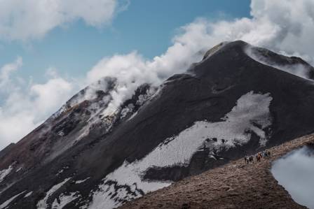
The Kunlun Volcanic Group, also called the Ashiköli Volcanic Field, is a volcanic region located in northwestern Tibet. The area is part of a larger volcanic zone that includes eight additional volcanic fields nearby. The volcanic field lies inside a basin that contains three lakes.
The volcanic activity in this region has created numerous lava flows, volcanic cones, and other volcanic structures. The rocks display diverse chemical compositions, with trachyandesite being the dominant type. Geological evidence suggests that fault systems in the surrounding region may have played an important role in controlling volcanic activity.
Dating studies indicate that volcanic activity in the field occurred from approximately 5.0 ± 0.6 million years ago to about 74,000 ± 4,000 years ago. In 1951, an eruption from Ashi volcano was reportedly observed, making it one of the youngest known volcanic events in China.
Geological Background
The Tibetan Plateau was created by the long-term collision between the Indian Plate and the Eurasian Plate. Potassium-rich volcanic activity has existed across the plateau for nearly 50 million years, but after around 8 million years ago, volcanic activity became concentrated mainly in northwestern Tibet.
The reason volcanism occurs in Tibet remains uncertain because the region is primarily shaped by continental collision rather than oceanic subduction, which is the typical cause of volcanic activity in many areas. Studies suggest that both southward movement of the Asian Plate and northward movement of the Indian Plate may have contributed to magma formation.
Material from the subducting plates may have influenced magma generation in northwestern Tibet, although isotope studies indicate that the Ashikule magma may not have originated directly from subduction processes. The formation of magma may have involved garnet-bearing crustal layers. More broadly, parts of the crust beneath northern and central Tibet are believed to contain partially melted zones at depths of around 55–60 kilometers.
Volcanic rocks younger than 350,000 years have been identified in both the Tengchong volcanic region in southeastern Tibet and the Ashikule volcanic area in northwestern Tibet. These are considered the only volcanic systems in Tibet with confirmed Holocene activity. Most volcanic areas in northwestern Tibet are located above 4,500 meters in elevation and remain difficult to access because of their remote environment.
The Ashikule volcanic field is one of nine volcanic regions in northwestern Tibet. Other volcanic fields include Dahongliutan, Heishibei, Kangxiwa, Keriya, Pulu, Qitai Daban, Quanshuigou, and Tianshuihai. Some of these volcanic centers are grouped together with Ashikule as part of the Yutian-Yumen volcanic zone.
A major seismic velocity anomaly beneath the southern Tarim region may be connected with Ashikule volcanism. Researchers have also proposed that a gap between the Tarim Block and the Indian Plate beneath the crust may provide a pathway for mantle material to rise and supply magma to the Ashikule volcanoes.
Geographic Location
The Ashikule volcanic field is located within the Kunlun Mountains, about 131 kilometers south of Yutian County in Xinjiang. It is among the highest volcanic regions on Earth. Due to its extreme altitude, dry climate, and isolated location, scientific research in the area has been limited.
The volcanic field occupies the southern portion of the Ashikule Basin, a large pull-apart basin in the western Kunlun Mountains. The basin covers approximately 700 square kilometers and lies at an elevation of about 4,700 meters, with the terrain gradually descending toward the southeast.
Crustal extension in an east-west direction may contribute to volcanic activity in the area. Numerous strike-slip faults are also present and may influence magma movement. The Altyn Tagh Fault crosses the volcanic field in an east-northeast to south-southwest direction, while other fault zones, including the Kangxiwa Fault, occur north of the basin and helped shape the development of the Ashikule Basin.
Volcanic Landforms
The Ashikule volcanic field contains around 11 to 14 major volcanoes formed from lava, pumice, and pyroclastic materials. The total volcanic volume is estimated at approximately 20 cubic kilometers. More than 70 volcanic cones, including many Quaternary-age cinder cones and lava structures, have been identified throughout the region.
More than 20 volcanoes are located in the eastern part of the field, with many rising several hundred meters above the surrounding landscape. The area contains exceptionally well-preserved cinder cones, as well as several silicic lava domes.
Lava from the volcanic field covers roughly 200–250 square kilometers of the Ashikule Basin. Over time, different types of surface coatings have developed on these lava flows, including some created through biological processes. The entire volcanic region extends across an area of approximately 4,820 square kilometers.
Xi Shan is the westernmost volcano in the field, measuring about 500 meters in diameter and rising 25–30 meters above its surroundings. Dahei Shan is the highest volcano in Ashikule, reaching an elevation of 5,104.6 meters and standing about 400 meters above its base. It has a distinctive V-shaped crater.
The Wuluke cone, located north of Wuluke Lake, is about 80 meters high and contains a crater lake. It has produced many lava flows, some of which entered the lake. Migong Shan lies east of Wuluke volcano. Yueya Shan contains a secondary cone approximately 60 meters high inside its 300-meter-wide crater, while nearby Maoniu Shan and smaller volcanic centers surround the area.
Other volcanic structures include Heilong Shan, a long volcanic ridge located on terraces of the Akesu River, as well as Mati Shan, Dong Shan, Binhushan, Gaotaishan, Yinshan, and Yizishan.
Ashi Volcano
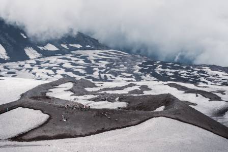
Ashi volcano, also known as Ka-er-daxi or Vulkan, is a trachyandesitic volcano located south of Ashikule Lake on a lava plateau. It stands at an elevation of approximately 4,868 meters.
The volcano has a cone about 350 meters wide. Its well-preserved summit cone rises around 120 meters above the surrounding area and contains a crater approximately 50 meters deep that opens toward the south.
Lava flows from Ashi volcano spread both northward and southward, covering an area of about 33 square kilometers. Some lava reached Ashikule Lake, contributing to the formation of the surrounding landscape.
Lakes and Basin Features
The Ashikule region contains three salt lakes: Ashikule Lake (also known as Ashi or Aqqikkol), Shagesikule Lake, and Wulukekule Lake (also called Wuluke or Ulugkol).
Ashikule Lake is approximately 5.5 kilometers long, while Wulukekule extends about 7 kilometers. Ashikule reaches a depth of around 40 meters and covers approximately 14 square kilometers. The lake was formed when lava flows blocked an ancient valley.
Wulukekule and Ashikule lakes are separated by volcanic lava formations. Between about 13,000 and 11,000 years ago, Ashikule and Shagesikule were connected as a single lake system. Nearby salt flats, or playas, produce mineral dust that affects the local environment. The basin is located within the upper reaches of the Keriya River region.
Rock Composition
The volcanic rocks of the Ashikule field are mainly composed of trachyandesite and trachydacite. The rock series ranges from tephrite and trachyandesite to trachyte and rhyolite.
Ashi volcano mainly erupted trachyandesite containing mineral crystals such as clinopyroxene, olivine, orthopyroxene, and phlogopite. Some rocks also contain gneiss xenoliths, which are fragments of older surrounding rock incorporated into the magma.
Compared with volcanic rocks from the Tengchong region, Ashikule volcanoes show higher thorium-to-uranium ratios. Thorium isotope research suggests that Ashikule magma formed through slower melting processes than magma in Tengchong.
The magma likely did not originate from water-related metasomatism. Instead, the source material may have been mafic to ultramafic rocks. Studies indicate that the magma of Ashi volcano formed through mixing between trachyandesitic magma and a more silica-rich component.
Research on Ashi volcano’s magma chamber suggests two different magma storage conditions. One group formed at temperatures of about 1,135–1,176°C and depths of 18–25 kilometers, while another developed at temperatures of approximately 1,104–1,143°C and depths of 13–18 kilometers.
Climate and Glacial History
The Ashikule Basin is among the driest regions of Tibet. Differences between surface exposure dating and potassium-argon dating results have been interpreted as evidence that some lava flows were once covered by snow and ice.
Scientists have suggested that during the Last Glacial Maximum, when temperatures were approximately 6–9°C lower than today, glaciers covered parts of the Ashikule volcanic field.
Volcanic History and Activity
Dating studies show that some volcanic rocks formed around 5.0 ± 0.6 million years ago and 2.7 ± 1.8 million years ago. Xi Shan volcano developed approximately 2.8 million years ago.
Mati Shan and a volcanic episode located about 120 kilometers north of Ashikule occurred between 1.63 and 1.21 million years ago. Most volcanoes in the region formed between 670,000 and 500,000 years ago, with additional periods of activity occurring between 440,000–280,000 years ago and 200,000–120,000 years ago.
Gaotaishan volcano is estimated to be about one million years old, while Binhushan formed around 370,000 years ago. A major volcanic episode around 270,000 years ago created several volcanic structures. Ashi volcano and the Wuluke cone erupted approximately 113,000 years ago, while many lava flows around Ashi were produced about 66,000 years ago.
Sedimentary layers beneath volcanic rocks have ages between 9,700 and 6,700 years, suggesting that volcanic activity may have continued into the Holocene period.
Recent Eruption and Current Status
The most recent reported eruption occurred on May 27, 1951, at Ashi volcano. According to a report from the Xinjiang Daily newspaper, soldiers constructing a road heard strong roaring sounds and observed a column of smoke rising from the volcano. The activity reportedly continued for several days.
A volcanic ash layer linked to this event has been identified in the Changce Ice Cap. However, no lava flows have been definitively connected to the eruption, and volcanic rocks within the field have not provided conclusive evidence of this event.
Another unverified account suggests that an eruption may have occurred during the 19th century. Today, the volcanic field is considered dormant. There is no confirmed evidence of an active magma chamber or ongoing ground deformation, although magma may still originate from deeper mantle sources.
Fumarolic activity has been observed on the northern side of Ashi volcano’s crater. The Ashikule volcanic field remains one of the few regions in China with evidence of relatively recent volcanic activity.
Earthquakes and Fault Activity
The magnitude 7.2 Yutian earthquake in 2008 occurred about 30 kilometers south of the volcanic field, near the intersection of the Karakax Fault and the Altyn Tagh Fault.
Additional earthquakes were recorded in 2012 and 2014. Volcanic activity in the region may be associated with the Longmu-Gozha fault system, while some volcanic structures have also been altered by tectonic deformation caused by fault movement.
अगला सहारा
समुद्र की गहराई में खोज करने के लिए 10 खूबसूरत जगहें
गीतिका

Breathtaking Hot Air Balloon Adventures You Can’t Miss
Tyler Jenkins
14 Incredible Destinations If You Need Peace and Relaxation
Emily Harrison

गर्भावस्था के दौरान कीवी फल खाने के क्या लाभ हैं?
तरुण

तुर्क्स कैप लिली लिलियम मार्टागन, ज़ोन 3 से 8
आदित्य
धीमी जीवनशैली क्या है?
रुचि